News: Fires in Valpo region and RM region. Smoke reaching Santiago and affecting people’s health and breathing.
Local report (Talagante): Here the sky is not quite grey, not quite blue, sort of in between. More blue overhead, more grey to the horizon. The smell of smoke/fire is permeating everywhere but not strong smell. However when I go outside I very slightly cough and my eyes are slightly irritated.
Solar panels energy production reduced by 15% here.
Here the air is a greyish yellow and you can definitely smell the smoke. I have severe respiratory allergies, so the smoke is really irritating my respiratory system.
The past two days, there was very visible offshore haze reminding me of that Eagle’s song when watching the sun set and yesterday, my phone went nuts with the ONEMI warning for Santo Domingo. There was a visible haze smoke layer that hung low over the Rio Maipo valley and surrounding areas south and east and by dusk, towards the east, the sky was black like an approaching gigantic storm front. During the day yesterday, the sky was blue no smell but when I went to the HiperLider, in the shaded entrance you could see actual ash particles swirling around in the coastal breeze. I have bronchitis and obviously scared nearby people and saw their worried COVID paranoia looks with those that had masks pulling them tight when I had a rare but unexpected coughing bout inside (after reading the other posts, I am convinced it was microparticles form the fires).
About the ONEMI phone alert, only works for phones bought inside Chile from authorized vendors. It will have the info on the box that it has this capability. The Santo Domingo fire was quite a number of kms south of me and not visible at all from my vantage point and I probably picked up the alert because of my line of sight to Santo Domingo across the Rio Maipo estuary. This is the third time Ive had a phone alert. The first was after the Coquimbo quake, the second was the first long distance overseas tsunami scare from a couple of years ago. For some reason, I did not receive the more recent second oversea tsunami nothing burger scare and reported it on the ONEMI website. At least there is some government actually doing work as I did pick up yesterday’s alert. And they edited the message to the initial alert screen, adding that it was a “Presidencial” ONEMI alert instead of the past message being an alert from ONEMI
in 2017, they (CONEF) had an interactive fire map where the public could see every wildire location in Chie., updated every few minutes. These interactive fire maps are common in the US and Canada, a public service. Why did they stop them here???
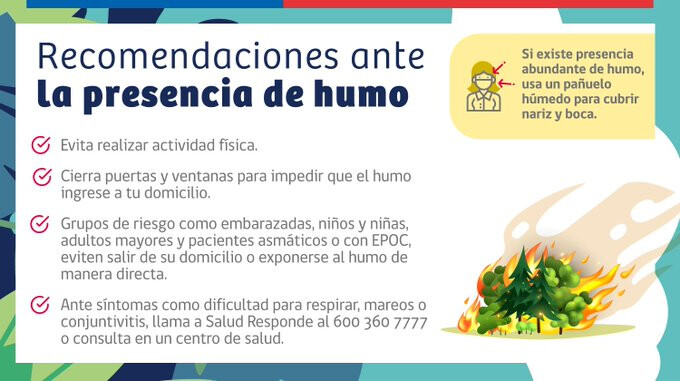
…el día miércoles había humo y ceniza en Santiago. El día jueves hubo poquísima information por parte de las autoridades acerca del combate de los incendios. La información que poseo es que hay una gran descoordinación entre personal de la CONAF, personal de bomberos, personal municipal, están todos descoordinados…
It’s what used to be called a SNAFU. Just imagine what the next big quake is going to be like with this lot in charge.
According to CONAF these fires are nearly always caused by human activity:
El origen de los incendios, recae en la acción humana. El 99,7% de los incendios se inician ya sea por descuidos o negligencias en la manipulación de fuentes de calor, o por prácticas agrícolas o por intencionalidad, originada en motivaciones de distinto tipo, incluso la delictiva.
We have clear skies in the Norte Chico, nothing much to burn round here
Another fire yesterday in the Isla de Maipo area. At first I thought it was quite close to us, like a mile away, but then I drove a mile and it looked like it was right next to there as well, that’s when I realized it was actually a very large fire about 5-10 miles away.
The smoke rose in a mushroom cloud formation a little similar to a nuclear bomb type formation, and fire was reported at 60-65 hectares.
Today is only the second cloudy day of the month, and both were the day after the fires. I suspect the fires seed and create a cloudy day the next day.